Central Alpine Trail 02 through Styria
obtížné Multi-day tours · Schladming
Fotogalerie


The following stage layout is just one of many variations - our tip: just start walking and let the impressions, whether landscapes or culinary temptations, drive and guide you. And if you find a place you particularly like, settle down. However, as we are travelling in alpine terrain throughout, good planning and, especially in the high season at the mountain huts, pre-booking your accommodation the following evening is essential.
1st day stage
Spital am Semmering (777 m) - Stuhleck (1,782 m) - Rosegger Schutzhaus (1,590 m) - Alpl (967 m)
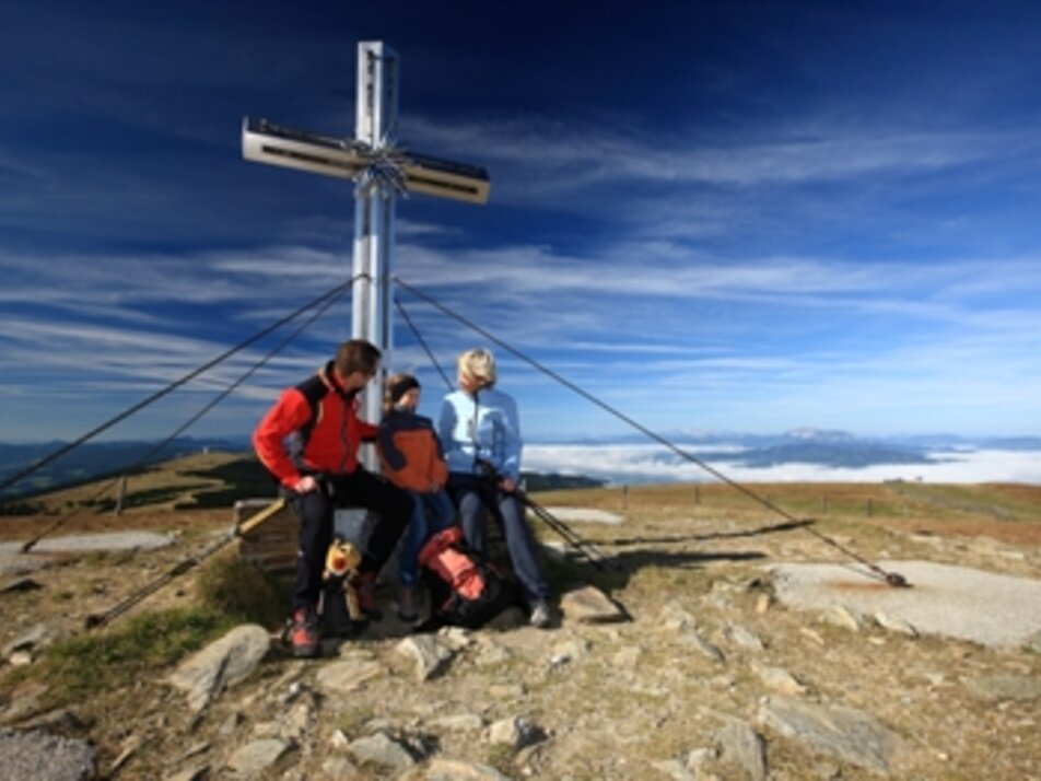
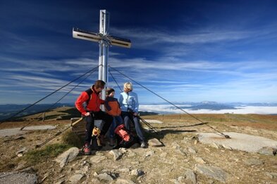
From Spital am Semmering we first head to the summit of the Stuhleck, the highest peak on the eastern edge of the Alps, with the Alois Günther Haus. On fine days, we can see about a third of the entire national territory as far as Hungary and Slovenia from here. The rest of the route takes us leisurely along the ridge into Peter Rosegger's forest home on the Alpl, where the writer's forest school still attracts numerous visitors year after year.
Further details
2nd day stage
Alpl (967 m) - Auf der Schanz (1,171 m) - Am Straßegg (1,163 m)
If we encounter pilgrims and pilgrims on today's stage, we shouldn't be surprised, as we are also travelling on a section of the Mariazell Trail. The path leads us through pleasantly shady forests towards the Teufelstein, one of the oldest places of worship in Austria. At the foot of this geological phenomenon, around 2 km after the Walserkreuz crossroads, we have to decide whether we have enough time and invest around 1 hour to visit the Teufelstein, or whether we continue straight away towards Schanzsattel. From here, across tranquil meadows and through romantic-looking forests, we reach the Gasthof Am Straßegg, our destination for today. Here we also have the option of taking the variant via Rennfeld with its refuge and the beautiful small town of Bruck an der Mur for the next two days (see stages 3A and 4A). Note: we recommend the variant via the birthplace of Peter Rosegger, an impressive place that was home to one of Austria's most famous writers and authors.
Further Details
3rd day stage
Am Straßegg (1,163 m) - Teichalm (1,172 m) - Mixnitz (447 m)
Today's stage takes us to the largest contiguous low mountain pasture area in Europe, the Almenland Nature Park, where we also leave the ‘From Glacier to Wine’ hiking route. Via the Sommeralm and the Teichalm at the foot of the Hochlantsch, we reach the entrance to the Bärenschützklamm gorge, which has been designated a natural monument. The Bärenschützklamm gorge is one of the most famous and beautiful rock gorges in Austria. The spectacular hiking trail is an impressive experience for all hikers and is probably particularly impressive in spring after the snow melts. Please note, however, that this section of the trail is very busy, especially at weekends in the opposite direction, i.e. uphill!
Further details
3rd day stage A (variation)
Am Straßegg (1,163 m) - Hochschlag (1,580 m) - Buchecksattel (1,275 m) - Ottokar Kernstock Haus (1,629 m)
After walking back a short distance, we branch off at a prominent crossroads in the direction of Rennfeld. From here we cross the summit of the Hochschlag, which is beautifully situated, and the Eibeggsattel to the summit plateau of the Rennfeld with the Ottokar Kernstock Haus as our destination.
Length: about 21 km
4th day stage
Mixnitz (447 m) - Pernegg (458 m) - Hochanger Schutzhaus (1,304 m)
We are now in the middle of the Mur valley, the second largest river in Austria. We continue upstream along the Mur for a few kilometres before leaving the valley to the west and heading uphill to the Hochanger Schutzhaus, which is beautifully situated above the historic town of Bruck an der Mur.
Further details
4th day stage A (variation)
Ottokar Kernstock Haus (1,629 m) - Bruck an der Mur (491 m) - Hochanger Schutzhaus (1,304 m)
We once again enjoy the impressive panorama from Rennfeld and then descend to the historic town of Bruck an der Mur, which impresses with its historic and modern architecture. A visit to the Schloßberg should be on the programme, as you have the best view of the town from here. The route then climbs steadily uphill to our stage destination, the Hochanger Schutzhaus, where we rejoin the main route of the Zentralalpenweg.
Length: about 17 km
5th day stage
Hochanger Schutzhaus (1,304 m) - Eisenpass (1,183 m) - Fensteralm (1,642 m) - Speikkogel (1,988 m) - Gleinalm (1,586 m)
Initially slightly downhill, the trail then leads over the ridge of the Herrenkogel and the Hochalm to the saddle of the ‘Diebsweg’, which was a transition from Leoben to Frohnleiten. Tip: take enough water with you in midsummer or fill up along the way, as the springs over the next few kilometres are very low in water during long dry periods. Today's rather long tour takes us across the Gleinalm alpine pastures to the Speikkogel, where we can enjoy a wonderful panorama before soon reaching the Gleinalm refuge.
Further details
6th day stage
Gleinalm (1,586 m) - Roßbachalm (1,780 m) - Oskar Schauer Haus (1,394 m) - Steinplanhütte (1,670 m) - Knittelfeld (638 m)
The beautiful little church ‘Maria Schnee’ welcomes us at the start. The trail continues across cosy alpine pastures and through shady forests towards Steinplan. A short ascent awaits us here before we continue steadily downhill to the town of Knittelfeld in the Mur Valley.
Further details
7th day stage
Knittelfeld (638 m) - Tremmelberg (1,194 m) - Seckau (834 m) - Ingering II (881 m)
Leaving the town of Knittelfeld, we head uphill to the Tremmelberg, where a beautiful lookout point has stood for several years and offers us a marvellous panorama. The next highlight of today's stage is Seckau Abbey in the town of the same name at the foot of the Seckau Alps. Before we head towards our destination for the day, we should take the time to visit the abbey.
Further details
8th day stage
Ingerning II (881 m) - Ingeringsee (1,221 m) - Kettentörl (1,864 m) - Hohentauern / Bergerhube (1,198 m)
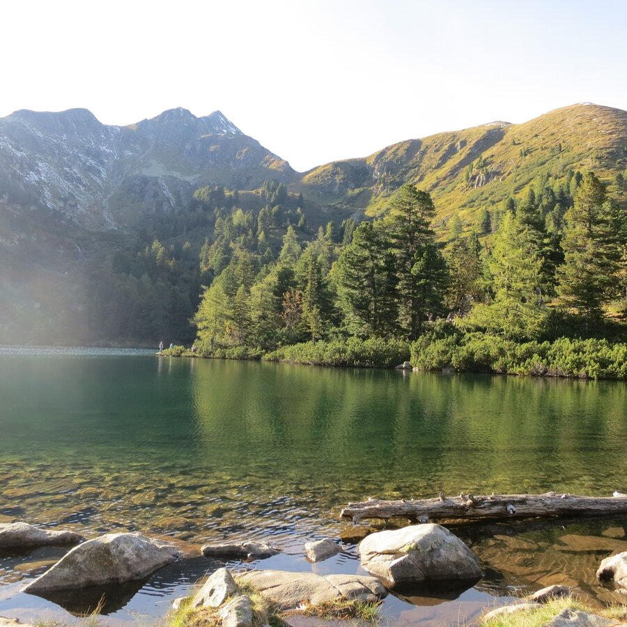
This stage marks the start of the Niedere Tauern and the Zentralalpenweg becomes an alpine tour. However, this also means that we will now encounter natural sites that are unrivalled. We start at the Ingeringsee, still an insider tip among the countless mountain lakes in the Tauern. We then ascend via a path over mountain pine-covered alpine pastures to the Kettentörl, before descending steeply again to our stage destination, the Bergerhube. Here we present the variant via Hohentauern, a beautifully situated village on the Tauern Pass with numerous accommodation options.
Further details
9th day stage
Hohentauern / Bergerhube (1,198 m) - Triebener Törl (1,905 m) - Sonntagskogel (2,229 m) - Hohentauern (1,274 m) - Edelrautehütte (1,706 m)
The first 2000 metre peaks await us on today's stage. Across alpine pastures and through high alpine terrain, the route leads uphill and downhill over several peaks to the beautifully situated village of Hohentauern, which can also be our stage destination in the variant described above (and as marked on this route). After the next stage becomes very challenging, we only climb up to the Edelrautehütte, one of the most popular destinations for holidaymakers in Hohentauern.
Further details
10th day stage
Edelrautehütte (1,706 m) - Kleiner Bösenstein (2,395 m) - Perwurzpolster (1,814 m) - Zinkenkogel (2,233 m) - Reiteckersattel (1,854 m) - Hochschwung (2,196 m) - Schattnerzinken (2,156 m) - Seitnerzinken (2,164 m) - Schwaberghütte (1,511 m)
Today's stage is definitely one of the most challenging on the Central Alpine Trail, as the route is a constant up and down in this beautiful landscape. And it is precisely this landscape that rewards you for all your efforts, as its vastness and unspoilt nature make it a real gem for nature lovers. Please note, however, that the stage is very demanding and the weather must therefore be stable.
Further details
11th day stage
Schwaberghütte (1,511 m) - Große Windlucken (1,857 m) - Breiteckkoppe (2,144 m) - Kreuzberg (2,045 m) - Planneralm (1,588 m)
First of all, a fairly long ascent to the Breiteckkoppe awaits us. After that, it's an easy uphill and downhill hike over several peaks to the Planneralm, which is a popular skiing area in winter and hiking area in summer.
Further details
12th day stage
Planneralm (1,588 m) - Karlspietze (2,097 m) - Donnersbachwald (976 m) - Mörsbachhütte (1,303 m)
From the Planneralm, the trail first leads uphill through mountain pine fields and across cosy alpine pastures to the Karlspitze, before descending to the village of Donnersbachwald, which is beautifully embedded in the surrounding mountain landscape. From here, right by the church, we continue along the Mörsbach stream on a gentle incline to the hut of the same name.
Further details
13th day stage
Mörsbachhütte (1,303 m) - Gstemmerscharte (1,996 m) Mößna (1,023 m) - St. Nikolai im Sölktal (1,127 m)
Today's tour takes us into the Sölktäler Nature Park. First, however, the steep ascent to the Gstemmerscharte awaits us before we head over soft alpine pastures towards the small village of St. Nikolai im Sölktal.
Further details
14th day stage
St. Nikolai im Sölktal (1,127 m) - Hohenseealm (1,543 m) - Schimpelscharte (2,273 m) - Rudolf Schober Hütte (1,667 m)
From the nature park to the mountaineering village could be the motto of today's stage, as we cross the Tauern and reach the Rudolf Schober Hütte, which is located above the mountaineering village of Krakautal in the middle of a pine forest. Today we are also entering the Schladminger Tauern, which, with more than 200 peaks over 2,000 metres above sea level and over 300 mountain lakes, has been designated a Natura 2000 European nature reserve.
Further details
15th day stage
Rudolf Schober Hütte (1,667 m) - Hubenbauertörl (2,051 m) - Rantentörl (2,166 m) - Breitlahnhütte (1,070 m)
Via the Hubenbaueralm, the trail leads us to the Törl of the same name and onwards via a path to the Hinterkarscharte, the highest point of today's tour. From here we descend steeply to a cirque lake and continue slightly uphill to Rantentörl. From here it's all downhill to the Breitlahnhütte, our final destination.
Further details
16th day stage
Breitlahnhütte (1,070 m) - Trattenscharte (2,408 m) - Wildlochscharte (2,488 m) - Preintalerhütte (1,657 m)
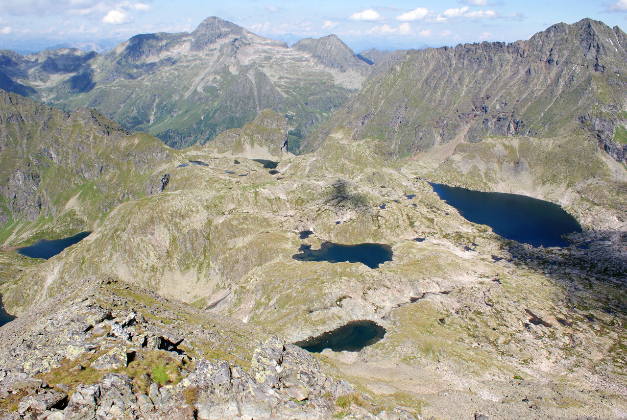
The trail leads across alpine pastures to the head of the valley. It now climbs uphill in serpentines to the Wildlochscharte. We then have our first views of the Klafferkessel, which is a highlight of the entire Central Alpine Trail. We soon reach the Preintalerhütte, our accommodation for the night.
Further details
18th day stage
Gollinghütte (1,641 m) - Rohrmoos Untertal (869 m) - Schladming (750 m)
Our last stage of the crossing of Styria on the Zentralalpenweg no longer leads along the Zentralalpenweg, but takes us from the Gollinghütte to Rohrmoos Untertal (trail no. 778), where we come across the National Geographic Wild Waters theme trail. This final stage takes us along this trail to Schladming, one of the most famous holiday regions in the Alps.
Length: approx. 18 km
Detaillierte Informationen zur Anreise finden Sie hier.
Accessible by train and bus.
Detailed information about arriving by ÖBB (Austrian Federal Railways) can be found at www.oebb.at or on the Verbundlinie Steiermark website www.busbahnbim.at
With Verbundlinie’s BusBahnBim route planner app, planning your journey has never been easier: simply enter towns and/or addresses, stop names or points of interest to check all bus, train and tram connections in Austria. The app is available free of charge for smartphones – on Google Play and in the App Store
- Emergency call mountain rescue: 140
Tips when reporting an emergency – Answer these six WH questions: What happened? How many people are injured? Where did the accident happen (are there GPS coordinates)? Who is reporting the incident (callback number)? When did the accident happen? What is the weather like at the site of the incident?
Proper backpack packing makes many things easier: Pack heavy things first. The water bottle should always be within reach in a side pocket. All the things that are often needed, such as sunglasses, camera or hiking map, belong on top. An emergency kit, including blister plasters, belongs in every rucksack and it is always advisable to dress in layers.Steiermark Tourismus
Tel. +43 316 4003
info@steiermark.com
If you would like to hire a tour operator, simply book with Steiermark Touristik, the official travel agency of Steiermark Tourismus:
Tel. +43 316 4003 450
The Steiermark Touren app, available free of charge on Google Play and the App Store (Android, iOS), offers detailed first-hand information: brief facts (length, duration, difficulty, ascent and descent/elevation gain, ratings), map, route descriptions, altimeter, compass, peak finder, navigation along the tour. You can also create your own personal lists of favourite tours and sites, store tours and destinations offline, use social media channels, and much more.
Fritz und Erika Käfer: Österreichischer Weitwanderweg 02 - Von der Ungarischen Pforte in die Niederen Tauern, Sektion Weitwanderer des OEAV, www.alpenverein.at/weitwanderer, weitwanderer@sektion.alpenverein.at
- Hiking map ‘Hiking WEST’ available at the information offices in the region.
- Schladming hiking map, 1:25,000, available at the Schladming information office.
- Hiking map Schladming-Dachstein, 1:50,000, available at the information offices in the region.
- Hiking guide Schladming-Dachstein by Herbert Raffalt, available at the information offices in the region.


